News Briefs
May 10, 2026: WXSIM Version 2026 is released! For details of what's new, see the revision history section on this site.
April 12, 2025: WXSIM Version 2025 is released! For details of what's new, see the revision history section on this site.
November 25, 2022: WXSIM Version 2022 is released! This is the first official release in over a year, and includes a major new feature:
the ability to incorporate forecast data from the European ECMWF model, often claimed to be the most accurate global forecast model. This can be averaged
using a user-defined weighting with NOAA's GFS model (very nearly as accurate as the ECMWF) to likely obtain better results than from either model alone.
There's also a new program in the WXSIM family, called euromix.exe, which allows the mixing of the data (automatically, if desired), along with a wide
range of visualizations of both GFS, ECMWF, and their mixed data. U.S. users can also still mix in some NAM (North American Mesoscale) model data.
August 1, 2020: WXSIM Version 2020 is released! This is the first official release in about a year, and includes a dozen new features,
changes, improvements, or bug fixes. The biggest news, though, is that the new WXSIMATE 8.0 has been upgraded from the original VB.Net I wrote
it in (starting in 2003) to Visual Studio 2019, and is now compiled in .NET Framework 4.7.2, so that it is very up to date with respect to internet
access, including new secure protocols. This should open up a long-term future for WXSIM/WXSIMATE!
September 3, 2017: On August 17, 2017, Tim Vasquez of weathergraphics.com
conducted an 18 minute interview with me about WXSIM, including its
ability to model temperature and cloud cover impacts of eclipses. However, I also provided a good description of the program and
its background. It's a chance to see who I am, and what this program is about!.
September 3, 2017: On August 21, 2017, I was fortunate to see the total solar eclipse from atop Bell Mountain near Hiawassee,
Georgia, with my wife, son, and a couple of friends. The view to the west was spectacular, as the moon's umbra approached at 1500 miles
per hour. This time-lapse video was shot by our friend Tom Smarch. He used a
fixed exposure, so the darkening is more dramatic than what we witnessed with our dark-adaptable eyes. One fascinating effect is that the cumulus
clouds in the distance are suppressed by the cooling in the moon's shadow, which helped keep things clear enough for us to see the whole show!
August 12, 2017: It now appears, from my inspection of forecasts for a couple
of sites in or near the path of totality, that the GFS model does NOT incorporate the
effects of eclipses! If I'm right, this may mean that WXSIM is alone in incorporating
solar eclipses into forecasts. I have just released Version 2017, Build 1.3, which takes
this into account by omitting 2-meter temperature effects from GFS (via WXSIM-Lite)
throughout the duration of the eclipse (first to last contact).
July 30, 2017: With the approach of the August 21, 2017 "Great American Eclipse" (which
I will be watching from the northeast corner of Georgia, as my second total eclipse,
the first being in 1972) I've just released WXSIM 2017, Build 1.2, with improved eclipse-effect modeling to make it easier
to set up and use. I'm not sure what, if any, other weather models are set up to incorprate
the cooling due to the moon's umbra sweeping across the earth, but WXSIM certainly is!
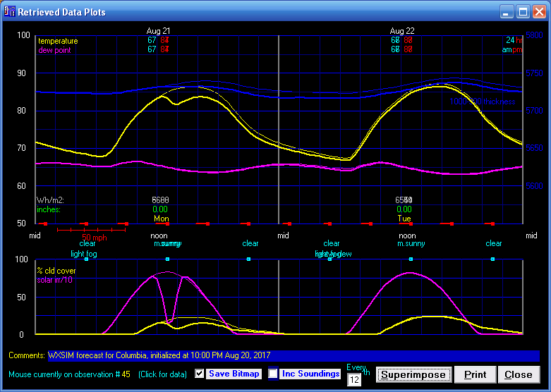
Here is a scenario I ran for Columbia, Missouri (in the path of totality) using typical
August conditions. The thick lines are with the eclipse; the thin ones are a comparison
with no eclipse. You can see solar irradiance plummet, and temperature and cumulus cloud
cover take dips in response, with even the next day's temperatures a fraction of a
degree cooler as a lingering repsonse.
Yes, the news notes below are extremely old, as on my previous version of the web site I mostly
ignored the section, while placing the news on the main page. I'm leaving the old stuff below
as legacy, just to emphasize that this site has a history!
July 16, 2012: Wow, almost four years since updating this page (most "news"
is placed on the main page). Probably the biggest news at this point is the
introduction of WXSIMPRO, the multi-site controller program for WXSIM users
who have two or more sites. This can be handled, less conveniently, by placing
copies of WXSIM in multiple folders, but that gets awkward past two or three
site. You can learn more here.
July 22, 2008: Another long-overdue update! Version 12.0 of WXSIM and 4.0 of
WXSIMATE are now availble, with new options and a new pricing structure.
A major renovation of the surface and upper air station databases has been
completed, based on stations actually reporting on several selected dates in
June and July, 2008. New WXSIM customizations will be able to draw on a worldwide
file of 8378 surface sites (including 473 buoys). Of the land-based sites, 5469
have METAR reports, 5920 have synoptic reports, and 3484 have both. The upper
air (RAOB) data base now has 764, worldwide.
February 10, 2007: I'm finally updating the "news"! Version 11.5
of WXSIM and Version 3.4.1 of WXSIMATE are released today. See the Revision
History section to see what's new.
August 16, 2005: After several months of work and a great deal of testing,
WXSIM Version 10.0 is released today!
January 8, 2005: WXSIM Version 9.5 is re-released, just with changes in manual.doc
and the in readme9.txt to reflect recent changes in the URL's for Florida State
University's data. Also, WXSIMATE is upgraded to Version 1.6.1 to reflect these
same changes. The new URL's are:
FSU RAW DATA (large files) - http://www.met.fsu.edu/rawdata/
INTERACTIVE TEXT: http://dweb.met.fsu.edu/index.pl/wxdata/textwx
ALSO, when you go to the buoy data, it's best to just use: http://coolwx.com/buoydata/
to get to the main page (I'd previously put the extension "data/" after that,
which seems to bring up a page that just sayd "Shame"!)
December 27, 2004: WXSIM Version 9.4 and WXSIMATE Version 1.4 are released.
These are now distributed via executable setup programs rather than the old
(and occasionally awkward) ZIP file method.
I am considering moving this web site, and perhaps changing my email address
in the next couple of months. This is not final yet, but if I do, I'll try to
set up forwarding so that you can easily find us!
August 21, 2004: WXSIMATE Version 1.1 is released. Improvements over Version
1.0 include a better-functioning progress bar, the ability to import data from
Weather Display as well as WeatherLink, and an updated URL for buoy data (see
below).
The FSU decoded buoy data URL changed a few days ago. It is now http://coolwx.com/buoydata/data/.
July 14, 2004: Version 9.0 is released. This a significant upgrade, especially
in that it can now import data from the new WXSIMATE companion program. See
New Features and Revision History for details.
A major renovation of the surface and upper air station databases has been
completed, based on stations actually reporting on several selected dates in
June and July, 2004. New WXSIM customizations will be able to draw on over 7200
surface sites (including nearly 350 buoys) and over 700 upper air sites, worldwide.
Also, note that the PSU buoy data has been moved to FSU. The new URL is: http://moe.met.fsu.edu/buoydata/data/
January 24, 2004: Version 8.9.1 is released. This a relatively minor upgrade,
but still has a couple of nice new features and a couple of bug fixes. See New
Features and Revision History for details.
November 8, 2003: Version 8.9 is released. This is the most significan upgrade
in years, with many new features and larger forms and graphics. See New
Features and Revision History for details.
September 5, 2003: Version 8.8.2 is released, primarily in quick response
to a change in the last couple of days to the READY data's column headings.
This change rendered earlier version incapable of importing READY cloud cover,
sea level pressure, and precipitation. The new version restores these capabilities.
A note regarding the READY site: I saw a notice on the site that access would
be denied to computers attempting to use automated programs or scripts to download
data from the site. WXSIM does NOT do this, and never has. The operators of
the site are concerned about two things: traffic jams caused by such automated
scripts or programs, and the fact that such a use (or abuse) of the site prevents
proper viewing of the site as a whole, possibly allowing data to be presented
without proper credit being seen. I do not know of any WXSIM users who might
have tried to access the site with automated scripts, but please don't. Just
take the couple of minutes to get the data manually, and enjoy the rest of this
very fine site!
July 15, 2003: Version 8.8 is officially released, with a number of new features
and improvements. The customization process has been improved and is more thorough
than ever, with usually about 250 advection sites and new capabilities for modeling
climatological normals. Also, in most cases I can thoroughly analyze home weather
station data, as well as that from major reporting stations, to fine tune to
your site. The price for customization is now $74.95.
June 28, 2003: Work is already underway on the next release, Version 8.8.
It will contain a few features designed to reduce the number of mouse clicks
needed to run the program, thus saving users a bit of time. A couple of other
improvements are planned as well.
You can now view a "webcast" interview with the author, discussing the program!
I was invited to appear on the HVAC Channel, watched by a fair number of Heating,
Ventilation, and Air Conditioning folks - perhaps not the number one market
for such a program - but a nice opportunity nonetheless! You can view the streaming
video and audio at http://www.hvacchannel.tv
. As of this writing, it's under "Idea Exchange" at the upper left of the
page; by the end of July I understand it will be in the archives. It's just
over 30 minutes long and includes a slide presentation as well as actual display
of the program in operation. I hope it will answer some questions, and it at
least lets you see who's on the other end of this program!
Finally, I would be interested to hear ideas regarding possible future upgrades,
modules, or related services. Here are a few ideas I'm considering:
November 3, 2003: WXSIM 8.9, released today, is a significant upgrade
(free for current users). See New Features and Revision History below).
June 17, 2003: WXSIM 8.7.2, released today, corrects a couple bugs that
were discovered recently see New Features and Revision History below).
March 9, 2003: WXSIM 8.7.1, released today, improves on the previous precipitation-type
decision routine and also introduces freezing level and 850-700 mb thickness
as outputs.
January 29, 2003: WXSIM 8.6, released today, can now handle the changes
to the READY site, including the change from AVN to GFS models (which is
mainly a renaming operation).
January 20, 2003: A couple of days ago the READY site had big changes in
meteogram text format. The old format is still available until February
1, 2003, but I've noticed a couple of changes even in that, which preclude
full reading by WXSIM 8.5 (though you can change a couple of headings in
the files to the old names and get it to work.
The good news is that I've already developed a new parsing procedure to
read the new format. I'm testing it now, along with a new feature that will
allow import of NGM and/or AVN MOS for advection sites, which will allow
much better advection data upon wind shifts. I hope to make this public
on this site in the next few days.
December 28, 2002: Version 8.5 is now available, including updates on
the manual and sample sites in the shareware package (now including Canberra,
Australia). This is the most significant upgrade in over a year. The new
files are available free for existing users here.
December 12, 2002: The READY site has had some format changes and improvements.
All data used by WXSIM is still readily accessible, perhaps a bit more conveniently.
May 4, 2002: Version 8.4.1 is now available. FSU's site has had some changes.
Currently, the large, raw data files for surface data are not available,
but the interactive text form is working, though it's URL has changed a
bit: here
March 3,2002: Version 8.2.9 is now available.
December 30, 2001: The READY site's 40 km ETA meteograms now go out to
84 hours instead of just 60. WXSIM Version 8.2 can now handle this longer
data set (earlier versions would have encountered an error).
June 7, 2001: Version 8 will likely be released before the end of June.
It will have new features including a new advection option, improved cloud
modeling from imported data, and new stability indices and convective outlooks.
The was a change in the READY Wind Flag format: it used to give U and V
wind components, and now gives direction and speed. Version 8 will handle
this. Meanwhile, you should be able to get accurate READY winds by separately
importing the U and V components (which is an option on the READY meteograms).
April 12, 2001: There has been yet another change (after two others in
the last two weeks or so) in NOAA's READY site's meteogram text data: the
year was changed from "01" to "2001". Version 7.3 properly imports the new
format as well as the older ones.
The FSL's MAPS site seems to be fully operational again, with MAPS as
well as RUC-2 soundings regularly available again as far as I can tell.